
© Railway Wonders of the World 2012-

Railways in Palestine
Modernity Invades the Holy Land
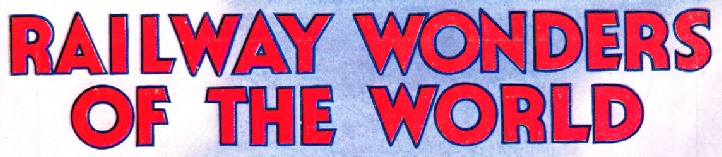
 AN IMPORTANT JUNCTION. The station of Lydda where lines from Jerusalem, Jaffa, Haifa and Kantara meet. Platforms 3 and 4, seen left, accommodate trains for Kantara and Jaffa respectively. It is said that St George, the patron saint of England, was buried at Lydda
A LONG-
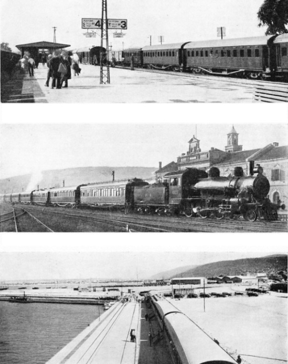
AT HAIFA HARBOUR, which was opened in October 1933. The Hedjaz Railway gives Haifa access to Transjordan and Syria. There is an entrance 600 ft. Wide and a space of 300 acres of sheltered water enclosed within the main and lee breakwaters for ships. The photograph shows a a tourist train at the port.
IN some ways the Palestine Railways and Operated Lines -
Palestine has an estimated population of about one million, the area being about 10,000 square miles. It is bordered on the west by the Mediterranean Sea, and on the south-
Transjordan exceeds 20,000 square miles in extent. It is inhabited by more than 300,000 people, but the western boundary is not clearly defined, and the population figures are only an approximation, as a great part of the country is desert, inhabited by nomadic and semi-

OLD AND NEW FORMS OF TRANSPORT meet at the railway goods sheds at Jerusalem. The railways of Palestine are partly controlled by the British Government and partly by the Palestine Government. There are three main groups of railways in the country.
It will thus be appreciated that it is no light task to maintain and work the railways in territory which is diverse in physical character, and is inhabited by people of various racial, religious, and political aspirations, who sometimes express their feelings by direct action. Indeed, the problems that have arisen since October 1, 1920, when the civil administration took over the railways from the British army, have been of an extraordinary variety. These have included planting of trees to keep the sands of the desert from blotting out the track, trying to stop nomads from stealing the rails, speeding up services, and cutting fares to combat intensive road competition; fighting floods and rock-
Haifa, the rapidly expanding Mediterranean port at the foot of Mount Carmel, is the headquarters of the railway admin-
 Jaffa, the Joppa of the Old and New Testaments, is the port of Jerusalem. The town is linked with mythology as the place where Perseus rescued Andromeda from the sea-
THE RAILWAYS OF PALESTINE and Transjordan. The three main groups shown are the Palestine, the Kantara Rafa, and the Hedjaz Railways. There are about 700 miles of track.
There are two railway gauges on the system, one the standard 4 ft 8½ in, and the other 3 ft 5¼ in, or 105 cm. The latter gauge is that of the Hedjaz Railway.
This unusual gauge is said to be the result of a mistake in the manufacture of the first steel sleepers which were sent to Damascus, the northern terminus of the railway. The section of the Hedjaz railway which runs in Palestine and Transjordan, is controlled by the Palestine Railways.
The somewhat complicated but interesting history of the railways began when the French, in 1888, secured a concession from the Turkish Government to build a metre-
To attack the Suez Canal the Turks built a line branching south from the Jaffa-

THE MAIN LINE AT HAIFA HARBOUR was diverted in 1933 to an area of 90 acres of new land reclaimed from the sea by dykes and breakwaters. Material dredged in connexion with the construction of the port was employed to consolidate the reclaimed area.
The British were forced to resort to fighting so that they could build their military line from Kantara East, on the Sinai side of the Suez Canal, across the desert to reach Palestine. Two Turkish attacks on the canal were defeated in February and March, 1915, and the British began to build the military railway on the standard gauge to drive out the Turks from Sinai and thus safeguard the canal. The Royal Engineers went on steadily, and were not interrupted until the line was nearing Katia. The Nile water was brought across the desert by pipe-
The Turks suddenly attacked in April, 1916, when about twenty-
In early 1917, however, things went awry with the British, who were foiled in their attempts to capture Gaza. A change in commanders was made, and General (afterwards Field-
Building a Military Line
Gaza, 236 kilometres (146 miles), now reached in five hours from Kantara East by the restaurant and sleeping-
Between Rafa and Gaza, at Khan Yunis, 131 miles, in an earlier war, Napoleon had one of the narrow escapes of his career. His main army took a wrong route that led into the desert. Napoleon and his staff rode into the town. The Arabs in the main square thought Napoleon and his staff were the entire French army, jumped on their horses and rode off in a hurry, instead of stopping to capture the emperor.

A BRIDGE REPLACEMENT over the River Kishon in Northern Palestine. The photograph shows the original structure below temporarily supporting the new bridge. Many railway bridges, built as temporary measures during the war, have since had to be renewed.
In the summer of 1917 the railhead of the British Army was at Deir al-
Gaza, 236 kilometres (146 miles), was one of the five cities of the Philistines of the Old Testament. When the Royal Engineers brought the railway to it, they also carried their pipe-
Allenby captured Beersheba, then Gaza, and pushed north along the coast as far as Jaffa, which fell on November 17, 1917. He gained the railway junction, and the Royal Engineers laid a line from Rafa to Beersheba, and took the lines as near Jerusalem as possible. Allenby then fought his battle and entered the city of Jerusalem, on December 11, 1917.

STEEL SLEEPERS have been laid on the line between Jaffa and Jerusalem. This railway was built in 1892 on the metre-
The Royal Engineers established railway connexion all the way up the coast as far as Acre, relaying the line from Haifa to Acre, and also that between Jaffa and Lydda on the Jaffa-
Palestine was finally conquered when Damascus was captured at the end of September, 1918. The building of their own railway lines, and the destruction of those of the Turks helped the British to achieve the victory. Because of the nature of the country, railways were the only means of handling the heavy transport required by both armies. After the war the line laid from Rafa to Beersheba by the British was dismantled, as well as that the Turks had built extending south through Beersheba.
Returning to Gaza and resuming the journey from Kantara East to Haifa, we proceed through the land of the Philistines to Majdal (161 miles), opposite Ascalon, which lies to the left of the line on the coast. Ashdod (169 miles) was one of the five ancient cities of the Philistines, which included Gaza and Ascalon. The name of Palestine has been derived from the word Philistine.
Soon after Yebna, 178½ miles, the line bends eastward away from the monotony of the sand dunes of the coast into what was once the country of the Tribe of Dan and is now an area of thriving Jewish colonies. Crossing the Jaffa-
Through Historic Territory
Proceeding towards Haifa, the line passes through olive groves to the Plain of Sharon. A short branch runs to Beit Nabala on the right of the line. The country is occupied by Jewish settlements, one of the oldest and most prosperous of which is Petah Tikvah (“The Gate of Hope”), which has a short branch line, eight miles long, as it lies on the left of the line from Ras el Ain (199 miles), and exports large quantities of oranges. The colonists contributed towards the cost of building this branch.
To the right of the line rise the mountains of Samaria. From Kilometer 325 (202 miles) a good view is obtained of Mount Gerizim (2,849 ft), on the top of which the ancient Samaritan sect still performs the Passover Sacrifice. At Kalkilieh, 207½ miles, the traveller sees Mount Ebal (3,077 ft) in the distance.
Tulkarem, 214½ miles, is the junction for the 105 cm branch of the Hedjaz Railway, which runs to Nablus for a distance of twenty-
This branch line has to climb up from the Plain of Sharon to Nablus, which lies in the long, narrow valley between Mounts Ebal and Gerizim, and is the Shechem of the Bible. Abraham pitched his tent here on entering the country, and set up an altar on a slope of Mount Ebal. It is the ancient home of the Samaritans, who still cling to it, and are the only distinct representatives of ancient Israel in Palestine. Of the total of 157 in the country in 1922, 132 lived in Nablus. The total increased to 195 persons by 1929, of whom 161 lived in the city, which is of considerable importance. Jacob’s Well, associated with the woman of Samaria, is just outside the town.
Proceeding from Tulkarem, the main line proceeds across the plain, Khudeira (225½ miles) being the station for a large Jewish colony. The line now approaches the coast again, and at Kilometre 380 (236 miles) it is possible to look back along the shore and see a large mound which is part of the ruins of Caesarea. That once mighty city was mainly built by Herod and became the civil and military centre during the Roman occupation. It was the scene of many fights between the Crusaders and the Saracens. Ahead can be observed the long slope of Mount Carmel, on the other side of which lies Haifa. The line passes Athlit (243½ miles), and the lighthouse and the Carmelite Monastery come into view on the top of Mount Carmel at Kilometre 406 (252 miles). From this monastery the Carmelite Order spread all over Europe.
The line goes round the northern end of Mount Carmel along the shore, opening up a view of the Bay of Acre, Haifa Station being 256 miles from Kantara East.
Haifa lies at the foot of Mount Carmel on the southern shore of the Bay of Acre. In 1933 the High Commissioner for Palestine opened the new harbour, which makes Haifa the most important port in this part of the Levant. The railway played an important part in the making of the new port. Palestine and Syria have since the the war of 1914-
To-
The Jaffa-
The 105 cm line to Acre, eleven miles in length, branches from the Hedjaz Railway at Acre Junction, about a mile and a quarter east of Haifa. The new workshops are near the Kishon River, which is crossed by a bridge with a centre span of
115 ft and two spans of 31 ft; a double track connects the workshops with Haifa Station. This track, with a third rail between the standard-
There is one disadvantage about Haifa, the water is bad for locomotives; but that has been overcome by sending the locomotives a short distance to Acre Bay, where the water is good, to take in fresh supplies when necessary.
The Jaffa-
The section of twelve and a half miles from Jaffa to Lydda is easily graded, but the climb up into the hills and to Jerusalem is steep. The broadening of the gauge compelled the railway to order six 2-

ACROSS THE SUEZ CANAL. A train of twelve-
Over thirteen miles of the section between Artuf (thirty-
The line from Jaffa climbs steeply after Artuf. Beyond Bittir, forty-
Turning from the standard-
On the Way to Mecca
After leaving Haifa the line crosses the River Kishon and runs across the Plain of Jezreel to Afule, where it crosses the road from Jerusalem to Nazareth, and soon after falls below the level of the sea as it enters the valley of the Jordan. The river is reached soon after passing Beisan, the Old Testament Bethshan, where many objects have been found showing the town to have been the centre of a serpent cult.
Above this place the line turns north along the Jordan, which it crosses at Jisr el Majame. This spot is 700 ft below sea-
The building of the Hedjaz Railway from Damascus to Medina, 1,105 miles, was a remarkable achievement which aroused the enthusiasm of Moslems in every part of the world except the Hedjaz, now part of the kingdom of Saudi Arabia, and the country in which are situated the holy cities of Mecca and Medina. Mecca is the birthplace of Mahomet, who is buried at Medina. The railway never reached Mecca, although it did reach Medina, from which point the pilgrims had to walk about 300 miles. Every Moslem is required by his religion to make the pilgrimage to Mecca at least once.

ORANGE WAGONS on a siding at Rehovot Station. The transport of oranges forms an important item in the freight traffic carried by the Palestine Railways; in recent years the export of oranges from Jerusalem has steadily increased.
The Turks said that the Arabs robbed, and killed the pilgrims who travelled down from Damascus by the overland route and that the railway would prevent this. On the other hand, the Arabs, who had a large measure of independence under the Turkish rule, said that the railway would enable the Turks to tighten their hold on Arabia. The determined attacks which were made on the construction gangs and the troops building the line seem to suggest that these were not made by isolated bands of wanderers trying to stop a railway that would prevent them from robbing pilgrims, but were the attacks of men trying to hinder what they considered to be a menace to their freedom.
A German engineer, Meissner Pasha, was given the task of building this railway, which was afterwards fated to play a vital part in the destiny of Turk and Arab. Field-
German and Turkish Pioneers
Use was made of a short length of line at Haifa. This had been built by a British company which had obtained a concession from the Turks but had afterwards failed. The conquest of the valley of the Yarmuk was a fine piece of engineering. The track had to be cut in the sides of the mountain, and taken across deep gorges and over rushing torrents. From Jisr el Majame, near Samakh, 700 ft below sea-
The section from Deraa to Maan was much easier. At first the line runs roughly parallel with the valley of the Jordan, which is about midway between the railway and the coast. Amman, where David took refuge from Saul, is connected with Jerusalem by a road which passes through Es Salt, crosses the Jordan by the Allenby Bridge, and passes through Jericho to Jerusalem.
The railway continues in a southerly direction to Maan, where traffic now ends. From time to time proposals have been made to repair it and reopen it to Medina, and even to link it with Mecca, but these have fallen through. The railway was of great value to the Turks in the war, Lawrence realized this, and began his campaign of dynamiting it. The line he destroyed had conquered great difficulties, as the country it traversed in the Hedjaz Peninsula varies in altitude from 200 or 300 ft below sea-

OUTSIDE JERUSALEM STATION. One of the first lines in the Holy Land was built from the capital to Jaffa, the port of Palestine. The original railway was granted a concession for seventy-
One attack by Bedouins was in the nature of a battle. The navvies were armed with rifles and supported the Turkish soldiers, but the railway builders had to stop work, although the raiders were driven off with the loss of a hundred dead. Batteries of artillery and other forces were sent to the aid of the Turkish commander, and a battle was fought, during which the Bedouins suffered such heavy losses that for some time they did not attack in force. When an attempt was made, however, to continue the line from Medina to Mecca, the tribesmen massacred all the workmen in the construction camp, and the project was abandoned.
As soon as the Palestine railways took over all the lines in Palestine and Transjordan, and the Kantara-
On March 31, 1934, there were four 120 horse-
0-
The fifty-
Trees as Windbreaks
There were also on March 31, 1934, ninety-
The rails on the Hedjaz line are of 45 lb section, and steel sleepers were used. Sections built thirty years ago are easier to maintain on this well-
Thousands of young trees grown in the railway nurseries at Lydda have been planted along the line at various places, and also at the workshops, to act as windbreaks and to prevent the sand from blowing on to the track.
The locomotives taken over from the Army were more numerous than the traffic required. Because of the inferior water at Haifa the engine failures due to leaky tubes and other boiler trouble have been frequent. When trade and industry recently increased in Palestine, the locomotives which were in good condition had to be run for a long while without being over-
Another point has been the keen competition of the roads. The road from Jaffa to Jerusalem took a good deal of traffic from the railway, as the locomotives hauling the standard gauge trains over this section were not powerful enough to be fast, and motor transport reaped the advantage.
The mileage of the railways, including sidings, is as follows: standard gauge, 396 miles; 105 cm gauge, 320 miles; total, 716 miles.
At the time of writing the prospects for the railways are better in Palestine than in many parts of the world, as both passenger and goods traffic are growing.
The Dead Sea, one of the most remarkable stretches of water in the world, is also helping the railways, as potash from it is taken by road to Jerusalem and then put on the railway for export.
IN THE SINAI DESERT. Mazar Station, situated on the Kantara Rafa Railway. This line was constructed by the Egyptian Expeditionary Force during the war of 1914-
You can read more on “The Hedjaz Railway”, “In the Nile Valley” and “The Taurus Express” on this website.